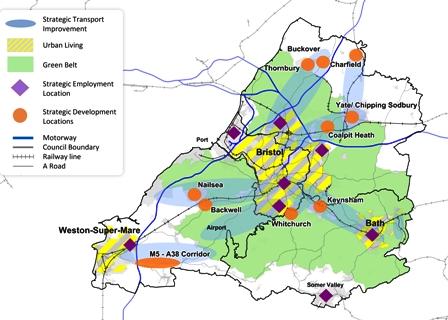
The Society has commented on the November 2016 consultation for the West of England sub-region’s emerging Joint Spatial Plan and Joint Transport Study, which set out possible ways forward for the period to 2036 in the context of a projected housing need of over 100,000 homes. Here is a summary of our comments.
Joint Spatial Plan (JSP)
We support much of the plan, whilst challenging the choice of scenarios and some of the development location proposals.
Choice of scenarios: our main challenge to the proposals is that the two scenarios selected – transport-focused, protection of the green belt – are not compatible. As the green belt covers such a large part of the sub-region, choosing development locations outside the green belt is likely to lead to greater transport costs. We would favour a scenario which follows the transport-focused approach more than the proposals presented in this consultation. Given the high projected expenditure on transport infrastructure, it is right to challenge whether a different choice of locations could reduce the expenditure needed. The choices of development location should be evidence-based, and the key evidence should be presented upfront, not just in technical documents which are hard to navigate.
Approach to the green belt: we urge the authorities to consider “green belt swaps”, an approach being considered elsewhere in the country which would meet the twin objectives of reducing travel and of protecting the green belt. This is where development on accessible green belt land is permitted provided that similarly sized areas of green belt are created elsewhere. This would surely allow more sustainable development adjacent to the main urban areas rather than in remote locations beyond the outer boundaries of the current green belt.
Erroneous thinking to justify road building: the proposed development location at Banwell/Churchill is justified on the basis it will help the case for road improvements in the area, including the A38 corridor into Bristol, which seems back-to-front erroneous thinking. This location does not make good use of existing public transport connections, and will add private motor traffic.
Joint Transport Study (JTS)
We support much of the Vision, particularly the aim to switch to more sustainable transport modes. But we question the amount of road expenditure. The Vision now needs to move on to the next stage, with more detail and prioritisation.
Level of ambition: The projected reduction in car use from 64% from 46% would look less impressive if expressed as a number of vehicles on the road, because of the significant increase in population over the period. This leads one to question whether the level of ambition for the move to sustainable modes is high enough.
Mix of expenditure: There are two areas of the proposed £7.5bn expenditure that are worth examining in more detail:
- expenditure on roads: whilst we strongly support that 65% (£4.9bn of the £7.5bn) of the total proposed expenditure is to be spent on sustainable modes, that still leaves £2.6bn expenditure on roads. The JTS maps show just how many road improvements are proposed, eg the A38 corridor, and numerous junction improvements. This will encourage car use. It is false to think that it is possible to solve congestion by building more roads. Given the high projected expenditure on transport infrastructure, it is right to challenge whether a different choice of JSP development locations could reduce the expenditure on roads that is needed.
- Light Rapid Transit (LRT) routes in Bristol: the proposed East Bristol and Gloucester Road LRT routes are difficult to deliver because the roads are narrow, and may need tunnelling. This engineering challenge is bound to be costly, but may be necessary if there is to be a step-change in travel by sustainable modes.
The Society’s full consultation responses may be found in these links: Joint Spatial Plan [PDF, 321KB] and Joint Transport Study [PDF, 287KB].
Alan Morris

